Pakūranga Road and Rā Hihi intersection
Rā Hihi - flyover above Reeves Road connecting Pakūranga Road with Pakūranga Highway opened to traffic in October 2025. The flyover improved travel times but afternoon peak traffic heading east from Panmure sees noticeable congestion along Pakūranga Road, particularly during afternoon peak travel times.
We've looked at how we can improve the intersection in a way that balances the needs of all users - those in cars, pedestrians, cyclists and bus passengers.
This page outlines the different options considered, our plan of action, and answers to questions you may have.
Our plan of action
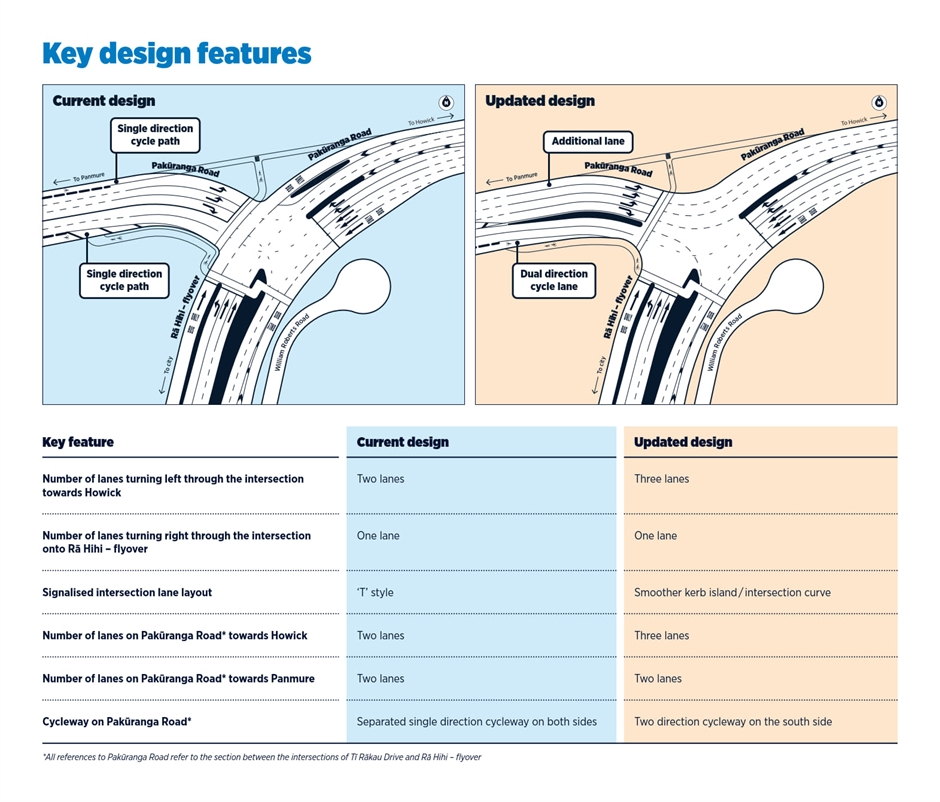
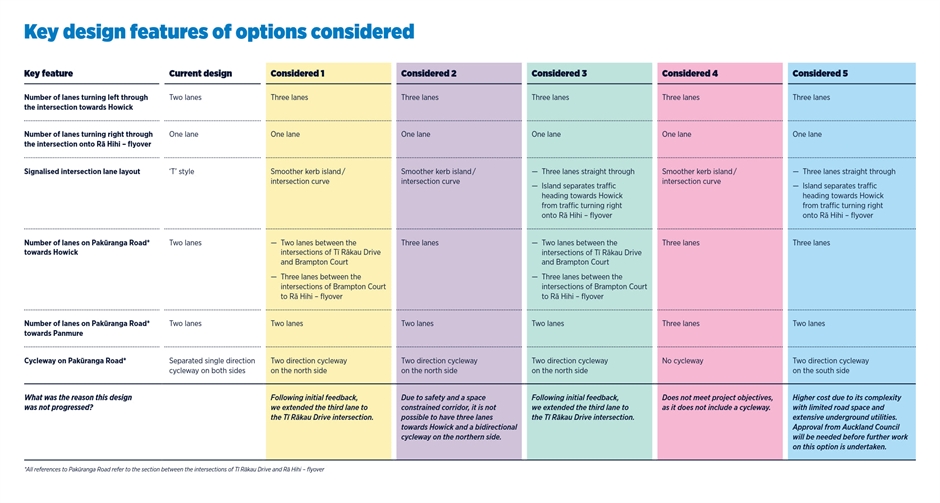
Work to add a third lane to the Pakūranga Road/Rā Hihi (Reeves Road) flyover intersection, allowing better traffic flow, will begin in June. It follows detailed technical assessments and engagement with elected members and neighbouring stakeholders to gather feedback. The updated design includes an additional lane between the intersections on Pakūranga Road at Tī Rākau Drive and Rā Hihi (Reeves Road) flyover to support the flow of vehicles travelling towards Howick and a bi-directional cycle lane on the southern side of the road.
An intersection design with three straight-through lanes and no curve was also investigated as an option. This option had comparable traffic throughput benefits; however, would have a higher cost due to its complexity with limited road space and extensive underground utilities.
Approval from Auckland Council would be needed before further work on this option is undertaken.
Next steps

Engagement Summary
A summary of the engagement findings is available here
Flyer
A summary of our plan of action is available here
Your questions answered
Why was the intersection designed this way?
The Eastern Busway Pakūranga to Botany section was designed in 2020 and follows the movement and place approach. These principles balance the need for transport corridors to move people and goods efficiently, with its role as places where people live, work, and interact.
The design of Pakūranga Road alongside Pakūranga Plaza emphasises the place function, supporting access and activity in the town centre. Rā Hihi - flyover emphasises the movement function, allowing people to travel more efficiently through the corridor. Together, these elements support both functions of the transport network.
This design approach was supported by the Government Policy Statement on Land Transport at the time and aligns with the strategic objectives set out in the Eastern Busway business case, which was approved by Auckland Council and the NZ Transport Agency.
Why have you chosen the updated design?
A range of factors have been considered as part of the decision making for the approach to the intersection changes. This includes:
- Feedback from stakeholders, the community and road users.
- Alignment with approved Detailed Business Case objectives and relevant consent conditions.
- Optimisation of the intersection for all road users while improving eastbound traffic flow.
What is the cost of the updated design?
The cost of delivering the updated design is approximately $2.5 million.
What is the cost of the design with straight-through lanes?
Work on completing the design for the straight-through lane option was not progressed as technical investigations identified significant engineering, utility, construction, and delivery challenges. As part of the decision-making process, a high-level assessment was undertaken to understand whether this option could be feasibly delivered and what the likely costs would be. That assessment indicated an estimated cost of approximately $11 million.
This estimated cost is above Auckland Transport’s funding threshold and would require additional approval from Auckland Council before any further design work could proceed.
What were the technical challenges associated with the straight-through lane option?
Design investigations identified several significant technical and construction challenges associated with the straight-through lane option. These included underground utilities, limited available road space, construction staging, and programme risk.
Underground utilities and infrastructure
A major 11KV power cable joint bay located beneath the road created concerns about vibration impacts from traffic and construction activity. Addressing this issue would require further investigation into alternative pavement designs and specialist acoustic and vibration assessments to determine whether impacts could be reduced sufficiently to obtain approval from utility providers. The area is already heavily constrained by existing underground services, retaining walls, and other infrastructure. Potential mitigation options, such as structural bridging solutions, may not be feasible within the available space. Relocating the joint bay would also be highly complex and could involve underground drilling across the road corridor while avoiding existing retaining wall footing and asbestos encased water infrastructure. This option would likely require approval from affected private landowners.
Construction and traffic management challenges
Construction of the straight-through lane option would be highly complex due to the constrained site conditions and the presence of existing underground infrastructure. Delivering this option would require a multi-stage traffic management approach similar to that used during construction of the current intersection layout. Significant enabling works, including underground utility relocations and stormwater works, would require a combination of day and night works. Pavement construction will also require extended continuous (24/7) works during a low-traffic period of extended duration such as over the Christmas and New Year period, to minimise disruption to road users.
Programme and delivery risk
Completing the remaining design work, securing third-party approvals, and potentially obtaining access to private property would introduce significant programme uncertainty and delivery risk. As the current programme of works in this area is scheduled to be completed by the end of the year, progressing this option would require a separate construction programme and delivery team.
Why is it more difficult to build three straight-through lanes compared to three curved lanes?
As part of the Eastern Busway project, we have upgraded underground utilities and intersections in the area to support future growth. This work included relocating underground services and creating access points to critical utilities beneath the island at the Pakūranga Road / Rā Hihi flyover intersection as part of the original design.
We cannot simply build a road over that area. Constructing straight-through lanes would require significant additional re-work, such as relocating underground high voltage cables, and maintaining access to existing water assets. Due to space constraints with other existing utilities including communication cables, gas and stormwater, it could potentially require additional land to accommodate these utilities in a safe location that is accessible without closing the road in the future for maintenance.
The added complexity is in the traffic staging due to the high number of vehicles using this road. To minimise impact on road users, the work will need to be undertaken in a low-traffic period (e.g. Christmas) and will involve significant traffic disruption. This is to enable construction of the new pavement and transitions back to existing pavement to ensure a robust roadway.
Will you continue to look into straight-through lanes at the intersection?
An intersection design with three straight-through lanes and no curve was also investigated as an option. This option had comparable traffic throughput benefits; however, would have a higher cost due to its complexity with limited road space and extensive underground utilities.
Approval from Auckland Council would be needed before further work on this option is undertaken.
Why are traffic lights needed at the intersection?
Traffic lights are required at this intersection to ensure safe movement of traffic to and from the flyover and towards Howick.
Will reducing lanes westbound towards Panmure result in more congestion?
No. The intersection already operates as two lanes in this direction, so delays are unlikely to increase.
How does the Eastern Busway benefit people who want to cycle?
The Eastern Busway is delivering 12km of walking and cycling facilities providing more choices for travel and enabling safe cycle connections.
Eastern Busway cycleways connect to existing cycle routes and off-road paths, including connection to the Panmure Basin Path, Rotary Walkway and the Esplanade Path to Lloyd Elsmore Park and Botany Downs. The cycleways also provide easy access to Pakūranga and Botany town centres as well as Panmure Train Station, the Eastern Busway stations and popular shops and amenities.
What does the future of cycling look like in East Auckland?
Auckland Transport is committed to providing travel choices and the long-term strategic intent for cycling and active modes in East Auckland remains unchanged. The Eastern Busway path on Tī Rākau Drive forms part of an aspirational 'Eastern Path', which connects Botany to the city centre and beyond with over 20km of dedicated cycleway. Pakūranga Road is identified as a major cycle connection and is a key 'spine' connection into the regional 'Eastern Path' cycle route, connecting key destinations, including multiple schools, residential suburbs and urban centres. For more information on walking and cycling, visit Biking & walking paths in Auckland.